From Midwestern Province to Bendel, the Journey of Delta State at a Glance
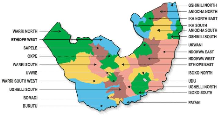
Did you know that Delta State on creation started with 12 local government areas (LGAs) and that the city of Warri is the biggest commercial city in the state?
Delta state was formally a part of the Mid-Western Region, which was a division of Nigeria from 1963 to 1991 before it was renamed as Bendel state in 1976. The Mid-Western Region was formed in June 1963 from Benin and Delta provinces of the Western Region, and its capital was Benin City. It was renamed a province in 1966, and in 1967 when the other provinces were split up into several states, it remained territoriality intact, becoming a state.
During the Nigerian Civil War, the Biafran forces invaded the new Mid-Western state, en route to Lagos, in an attempt to force a quick end to the war. While under Biafran occupation, the state was declared the "Republic of Benin". As Nigerian forces retook the region, the republic collapsed only a day after the declaration when Nigerian troops captured Benin City.
In 1976 the state was renamed Bendel. It was divided into Delta State and Edo State in 1991, composed of the old Benin and Delta Provinces. The Benin provinces had Edo speaking people while the Delta province had Okpe, Ijaws, Isekiri, Urhobo, Isoko and Ukwuani speaking people excluding Ika and Aniocha.
The area known today as Delta State became an autonomous entity on August 27, 1991, created from the then Bendel State by the then regime of General Ibrahim Badamasi Babangida (IBB). The state is named after the delta region of the River Niger, with its capital situated at its northern end in Asaba.
Warri is the biggest commercial city in the state. Other major towns are Agbor, Ughelli, Oleh, Ozoro, Oghara, Sapele, Koko, Burutu, Okpanam and Ogwashi-ukwu. Delta State can be considered a miniature version of Nigeria, with various ethnic groups.
Delta State shares common boundaries with Edo and Ondo States to the north west, Imo and Anambra to the north east, and Rivers and Bayelsa States to the south east. In the south west and south it has approximately 122 kilometres of coastline bounded by the Bight of Benin on the Atlantic ocean.
Delta State started with 12 local government areas (LGAs). These LGAs were further split into 19 on September 27, 1991, and to 25 in 1997. A master plan for its capital, the Asaba Capital Territory, with an estimated area of 762 sq. km designed to transform Asaba into a modern metropolis, is vigorously pursued by the state government.
On the location of Delta State geographically, it lies approximately between Longitude 5°00 and 6°.45' East and Latitude 5°00 and 6°.30' North. Delta State covers a landmass of about 18,050 sq km of which more than 60% is land. It is bounded in the North by Edo State, the East by Anambra State, South-East by Bayelsa State, and on the Southern flank is the Bight of Benin which covers about 160 km of the State's coastline. Delta State is generally low-lying without remarkable hills. The State has a wide coastal belt inter-lace with rivulets and streams, which form part of the Niger-Delta.
Delta State has an estimated population of more than five million with Urhobo, Itesekiri, Ijaw (Izon), Isoko and Anioma (Igbo) as the main ethnic groups. These groups share ancestral and traditional administrative systems, evident in their dress, language, festivals, music and folklore. The people referred to as Deltans are hospitable, enlightened, resourceful and hardworking.
Delta State is situated in the tropics and therefore experiences a fluctuating climate, ranging from the humid tropical in the south, to the subhumid in the northeast. The lessening of humidity towards the north is accompanied by an increasingly marked dry season. The average rainfall is about 266.5mm in the coastal areas and 190.5mm in the extreme north. Rainfall is heaviest in July. Temperature increases from the south to the north. In Warri, located in the south, for example, the average daily temperature is 30°C, while the temperature in Asaba in the north eastern area is 44°C.
There are various solid mineral deposits within Delta State - crude oil, industrial clay, silica, lignite, kaolin, tar sand, decorative rocks, limestone, etc. These are raw materials for industries such as brickmaking, ceramics, bottle manufacturing, glass manufacturing, chemical /insulators production, chalk manufacturing and sanitary wares, decorative stone cutting and quarrying.
Sources: Nigeria Galleria | Wikipedia
#penglobalhistory #delta
